ADVANCED LAMINATED WALL MAPS: World
In stock
Connect with a representative to create a custom curriculum for your district.
Four feet wide, these laminated, markable/washable poster-style wall maps (use dry erase markers) make superb classroom tools.
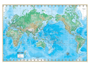
The "political" map is actually physical-political, with a five-color scheme distinguishing nations, shaded relief indicating mountain ranges, rivers shown in unusual detail, and national flags shown in a strip at the bottom. On the physical map, red lines indicate boundaries, shaded relief indicates mountain ranges, and colors indicate altitude.
This title is part of the series: ADVANCED LAMINATED WALL MAPS: World
| Size | Political map: 36"h x 48"w. Physical map: 30½"h x 50"w. |
|---|---|
| Publisher | UniversalMap |
| ISBN | 9780762575770 |