DELAWARE DESK MAP
Explore Delaware’s Geography and History Up Close!
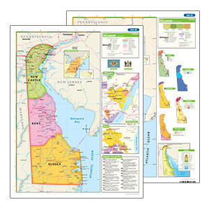
This Delaware Desk Map is the perfect tool to help your students explore the First State’s geography, political boundaries, and natural features—right at their desks. With a double-sided design, students can easily switch between a political map showcasing Delaware’s counties and major cities, and a physical map highlighting its diverse terrain, elevation, and land use.
Measuring 17″h x 22″w and laminated for durability, this desk map is built to handle daily classroom use while staying in top shape. Its markable surface makes it ideal for interactive lessons—students can write on it with dry-erase markers, wipe it clean, and start fresh for the next lesson.
To guide your lessons, a 16-page teacher’s guide is included with thoughtful questions that lead activities and reproducible student handouts, making it easy to turn geography into engaging, hands-on learning.
With easy-to-read symbols for population, land use, and major physical features, this desk map helps bring Delaware’s geography and history to life in a visual, engaging way. Insets include fascinating details about population density, elevation levels, and even Delaware’s rich Native American history.
Key Features:
Bring Delaware to Your Classroom!
With this durable and interactive desk map, plus a helpful teacher’s guide, students can dive into Delaware’s geography and history in a hands-on way. Whether exploring its cities or its natural landscapes, this map makes learning engaging and easy.”
| ISBN | 9780782538236 |
|---|