
ENVIRONMENTAL INTERACTIONS MAPS
Select your Materials
Connect with a representative to create a custom curriculum for your district.
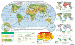
Designed for teaching about human-environment interactions, large U.S. and world maps depict natural regions (grassland, forest, desert, tundra, and cropland) while thematic insets illustrate changes in the environment over time. In addition to natural regions, the world map shows ocean pollution and the U.S. map features urban areas.
Thematic insets:
- temperature change
- air pollution
- urbanization
- sea level change
- deforestation (world map only)
Markable and erasable, the poster-style maps are printed on durable, waterproof material.
| Size | 32"h x 54"w |
|---|---|
| Publisher | The George F. Cram Company |
| Grade | 5–12 |
 U.S. map