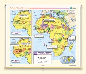
GHANA EMPIRE, 1050/MALI EMPIRE, 1337/AFRICAN EMPIRES AND STATES, 1530
Map on spring roller with backboard
Connect with a representative to create a custom curriculum for your district.
The Ghana and Mali insets show the extent of each empire. Plus major cities and trade routes. The main part of the map shows the entire African continent, locating the Songhai Empire, the Swahili and Hausa city-states, other important cultural groups and civilizations, trade routes, and significant developments.
This title is part of the series: THE NYSTROM COMPLETE WORLD HISTORY MAP SET