GROWTH OF AMERICA MAP
Map
Connect with a representative to create a custom curriculum for your district.
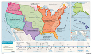
This map depicts the major annexations, purchases, and cessions that brought America from 13 colonies to 50 states, and a timeline lays out milestones in the country's expansion along with the date each state entered the union.
Present-day boundaries are also shown. Markable and erasable, the poster-style map is printed on durable, waterproof material.
| Size | 32"h x 54"w |
|---|---|
| Publisher | Cram |
| Grade | 5–12 |
| ISBN | 9780782526349 |
 Discussion guide