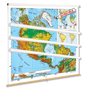
SCULPTURAL RELIEF CONTINENTS AND REGIONS MAP SERIES
Colors dramatically express elevations—seven colors to distinguish elevations on land and three shades suggesting ocean depths. Also shown: longitude and latitude, capital and major cities (with populations indicated by both type size and symbol size), and various types of landforms and water features. Thematic insets vary from map to map, but generally show rainfall, population, growing season, land use, and a cross-section elevation profile. Each map measures 54″h x 65″w and comes mounted on a spring roller in a steel frame designed for hanging from a backboard or from a one-inch map rail (not included).
Coordinated desk maps and five specialized map sets are available:
- The 7-map World and Continents set includes Africa, Asia, Australia, Europe, North America, South America, and the world.
- The 7-map Continents and Regions set includes Africa, Asia, Australia</a, Europe, Middle East, North America, and South America.
- The 6-map Continents and Regions set includes Africa, Asia, Europe, Middle East, North America, and South America.
- The 5-map Eastern Hemisphere set includes Africa, Asia, Australia, Europe, and Middle East.
- The 4-map Western Hemisphere set includes Canada, Middle America, North America, and South America.
- The 4-map World/U.S. Dual Map Teaching Set has two labeled and two unlabeled maps that help students understand physical geography and its political implications.
This title is part of the series: SCULPTURAL RELIEF CONTINENTS AND REGIONS MAP SERIES
| ISBN | 9780782540833 |
|---|

