SCULPTURAL RELIEF DESK MAP OF EUROPE AND ASIA
Geography That Pops—From the Alps to the Himalayas
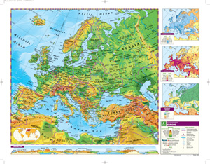
Give students a bold, hands-on look at the continents of Europe and Asia with this double-sided Sculptural Relief Desk Map. Vivid colors express elevation, while shaded relief gives shape to the land—making mountain ranges, plains, and river basins easier to see and understand at a glance.
Each side focuses on a single continent, with unobtrusive country borders that preserve the visual impact of the physical landscape. Capital and major cities, landforms, water features, and lines of latitude and longitude round out the labeled features. It’s a detailed yet uncluttered way to connect students with the geography they’re studying.
The map measures 17″h x 22″w, is laminated for durability, and is markable with wet-erase markers—perfect for daily classroom use. Available as a single map or in sets of 5, 30, or 100 to fit any classroom size or budget.
Key Features:
This title is part of the series: SCULPTURAL RELIEF DESK MAP OF EUROPE AND ASIA
| Size | |
|---|---|
| Publisher | Nystrom |


