SCULPTURAL RELIEF U.S. DESK MAP
A Hands-On Way to Map the U.S.—Literally
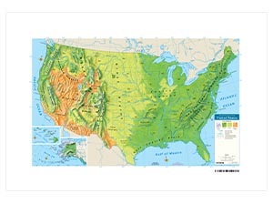
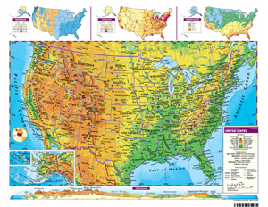
The Sculptural Relief U.S. Desk Map gives students a vivid look at the landscape of the United States—no 3D glasses required. Color-coded elevation and shaded relief help landforms leap off the page, while unobtrusive state borders keep the focus on physical geography. One side is fully labeled, the other is blank—so students can test their map skills, not just their memory.
Capital and major cities, rivers, lakes, mountains, and coordinates are all clearly marked. Insets provide extra context, showing population, land use, climate, and elevation patterns across the country. Whether students are tracing the Rockies or labeling the Great Lakes, this double-sided desk map brings physical geography to life (without saying “to life”).
It measures 17″h x 22″w, is laminated for durability, and markable with wet-erase markers—perfect for everyday classroom use. Available individually or in sets of 5, 30, or 100.
Key Features:
This title is part of the series: SCULPTURAL RELIEF U.S. DESK MAP
| Size | |
|---|---|
| Publisher | Nystrom |