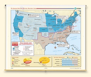
THE UNION AND THE CONFEDERACY, 1861–1865
Map on spring roller with backboard
Connect with a representative to create a custom curriculum for your district.
Shows free states, slave states, and territories in which the Supreme Court allowed slavery. Also shows the boundary between the U.S. and the CSA, and state and national capitals. One inset at the bottom has pie charts showing percentages of the population in the Union or the confederacy of white slaveowners, whites who didn’t own slaves, slaves, and free blacks. The other inset has a chart showing the division of natural resources (farm land, population, railroads, factories) between the Union and the Confederacy.
This title is part of the series: THE NYSTROM COMPLETE U.S. HISTORY MAP SET