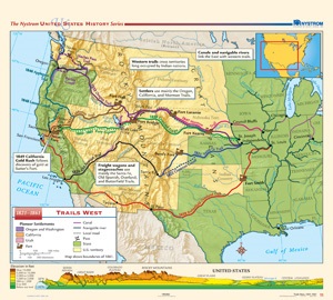
TRAILS WEST, 1821–1861
Map on spring roller with backboard
Connect with a representative to create a custom curriculum for your district.
Color shading shows pioneer settlements in Oregon/Washington, Utah, and California; symbols denote forts and passes; and lines indicate canals, navigable rivers, and local roads. The map also uses color to distinguish states from territories, and, at the bottom, a stratigraphic cross-section shows elevation of the regions of the U.S.
This title is part of the series: THE NYSTROM COMPLETE U.S. HISTORY MAP SET


