Oregon Shaded Relief Map
This full-color state map includes shaded-relief topography, county names and borders, major and capital cities, main rivers, and other large bodies of water. It includes insets providing a state flag, a locator map (within North America), a table of statistics, and text with high-interest historical, anecdotal, and geographical information.
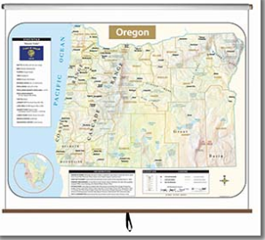
Oregon Wall Map
This full-featured state map is political with shaded relief; it shows county boundaries, major transportation routes, points of interest, physical features, and capital, major, and sizable cities with population ranges indicated by type size and/or symbol size.

Meet your state curriculum specialist
Lauren O'Brien
Oregon Curriculum Specialist
Lauren started her teaching career in Madison, Wisconsin where she taught 7th grade Social Studies. She moved up to the Minneapolis area in 2019 where she took another middle school teaching job before transitioning into the world of curriculum.